
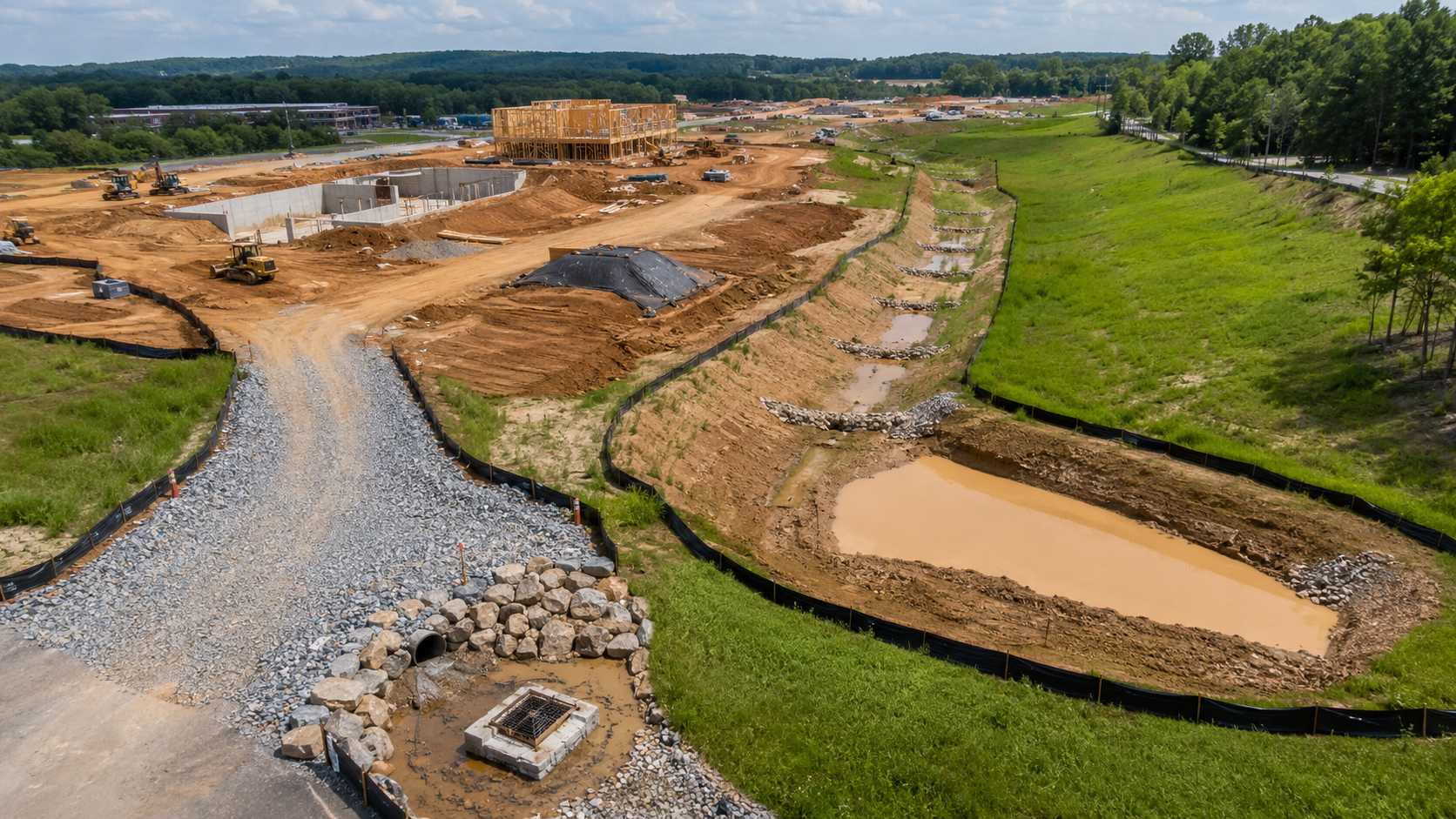
An erosion control project lifecycle is a seven-stage process designed to manage risk, maintain regulatory compliance, reduce pollution, and establish permanent vegetation on a construction site.
From initial pre-construction planning through post-construction stabilization, the lifecycle ensures that Best Management Practices (BMPs) evolve with changing landscape conditions.
According to the EPA’s 2022 Construction General Permit (CGP), an operator’s obligation to maintain these controls is continuous, running from the very first land disturbance until final stabilization is achieved across every disturbed area.
To achieve full compliance, an erosion control project progresses systematically through seven critical phases:
- Phase 1: Pre-Construction Planning & SWPPP Development: Assessing topography, soil characteristics, and receiving waters to map out initial BMP sequencing.
- Phase 2: Site Preparation & Vegetation Removal: Installing initial perimeter controls before land clearing begins.
- Phase 3: Mass Grading: Managing high-risk sediment runoff during major earth-moving operations.
- Phase 4: Infrastructure & Utility Construction: Protecting newly installed storm drains, trenches, and utilities.
- Phase 5: Vertical Construction: Adapting BMPs to handle material stockpiles and building footprints.
- Phase 6: Final Grading & Site Finishing: Preparing the final topsoil layer for seeding and stabilization.
- Phase 7: Permanent Stabilization & Permit Termination: Achieving the required vegetation to safely terminate the CGP coverage.
In this guide, you’ll learn about each stage of the erosion control lifecycle, detailing the changes at each successive phase and how your SWPPP must adapt to keep your site fully protected.
Phase 1: Pre-Construction Planning and SWPPP Development
During the pre-construction planning and SWPPP development phase, operators assess site-specific drainage patterns and soil characteristics to design a comprehensive Stormwater Pollution Prevention Plan (SWPPP) and determine the project’s BMP installation sequencing.
Under the EPA’s 2022 Construction General Permit (CGP), the SWPPP must be fully completed before submitting a Notice of Intent (NOI), ensuring that all erosion and sediment controls are planned before any land disturbance begins.
To establish regulatory compliance and site stability, this phase focuses on three core objectives:
- Soil Erodibility Assessment: Using the USLE K-factor to identify highly erodible subsoil horizons (B and C horizons) exposed by grading, which require more aggressive stabilization due to higher clay content and lower structural stability than topsoil.
- Drainage Pattern Mapping: Pre-mapping existing sheet flows, concentrated flow paths, and natural swales to properly position perimeter controls and prevent runoff from exceeding BMP capacities.
- BMP Sequencing: Organizing construction schedules so that critical perimeter controls (such as silt fences, sediment basins, and check dams) are fully functional down-slope before any up-slope earth-moving or land disturbance begins.
Phase 2: Site Preparation and Vegetation Removal
During the site preparation and vegetation removal phase, operators clear existing vegetation, remove surface organic matter, and strip topsoil, creating the highest per-acre erosion risk of the entire project lifecycle.
Undisturbed vegetation naturally reduces erosion by over 90% compared to bare soil.
To minimize risk under EPA guidelines, this transition must be strictly managed to prevent mass clearing from exposing the site prematurely.
To maintain compliance and protect vulnerable downslope areas, this phase requires three critical controls:
- Phased Clearing: Clearing only the specific acreage actively needed for the immediate next phase of construction to limit the timeline of bare soil exposure.
- Topsoil Stockpile Management: Positioning stripped topsoil on the upslope side of sediment controls and applying temporary stabilization within the mandated 14-day CGP window.
- Precedent Perimeter Controls: Installing and verifying that all downslope silt fences, fiber rolls, and perimeter BMPs are fully functional before any upslope land clearing begins.
Phase 3: Mass Grading
During this stage, operators perform bulk earth-moving, such as land clearing and brush hogging, to shape the site to its final design grades.
This process creates the largest disturbed-soil footprint and produces highly erodible cut-and-fill slopes.
Operators must actively evaluate and adjust controls based on actual post-grading topography rather than pre-disturbance assumptions.
To manage runoff dynamics on a newly graded landscape, this phase focuses on four key priorities:
- Cut Slope Stabilization: Applying temporary seeding or erosion control blankets within the 14-day CGP window to vulnerable, low-organic subsoils exposed by cutting.
- Intermediate Drainage Controls: Installing temporary sediment traps between graded and ungraded zones to prevent runoff from cascading across active work areas.
- Post-Grading BMP Reassessment: Reviewing and relocating perimeter controls to align with the site’s newly established micro-drainage networks and flow paths.
- Check Dams in Temporary Swales: Placing rock or fiber check dams in newly graded temporary channels to reduce concentrated flow velocity and prevent internal channel erosion.
Phase 4: Infrastructure and Utility Construction
Next, operators install roads, utilities, and storm drains, creating linear disturbances that cut across existing drainage patterns.
This phase introduces compacted, impervious surfaces that rapidly increase runoff volume and velocity, while open utility trenches risk redirecting subsurface groundwater into unexpected surface discharge points.
Trench spoil management uses temporary covers or diversion berms to prevent loose excavated dirt from washing downslope before backfilling.
Immediate inlet protection requires installing sediment controls on new storm drains as soon as they are installed to keep mud out of the sewer system.
Finally, regular maintenance of construction entrances involves frequent rock replacement to handle heavy utility truck traffic and prevent off-site trackout.
Phase 5: Vertical Construction
During the vertical construction phase, operators erect structural framing and enclosures, which transition much of the site’s footprint into permanent, impervious rooftops and foundations.
While the total area of active earth-moving decreases, the remaining unpaved perimeter and material stockpiles are highly susceptible to erosion driven by concentrated stormwater cascading off new building envelopes.
To isolate building-perimeter erosion and manage concentrated structural runoff, this phase targets four core objectives:
- Managed Rooftop Discharge: Installing temporary downspout extensions to safely direct roof runoff away from the foundation and adjacent bare soil areas.
- Envelope Perimeter Protection: Maintaining aggressive sediment barriers directly adjacent to the building envelope where concentrated runoff meets unpaved ground.
- Delayed Landscape Stabilization: Applying temporary cover within the 14-day CGP window to any disturbed areas sitting idle while waiting for final, late-stage landscaping.
- Designated Concrete Washout: Managing highly alkaline structural waste inside lined, designated washout areas to protect surrounding soil chemistry and vegetation potential.
Phase 6: Final Grading and Site Finishing
Operators establish precise finish grades for landscaped beds, correct localized drainage slopes, and spread topsoil in preparation for final seeding.
Since this phase re-disturbs previously stabilized soils to achieve aesthetic tolerances, it creates a temporary, high-risk window for off-site sediment transport.
Existing perimeter BMPs must remain fully functional and cannot be removed in anticipation of project completion.
To successfully navigate this final window of elevated erosion risk, the site finishing process must coordinate topsoil seeding with existing BMPs to ensure that all necessary perimeter controls are intact and don’t risk erosion of new soil.
Phase 7: Permanent Stabilization and Permit Termination
Once construction activity has ceased, operators transition the site from temporary construction BMPs to permanent, self-sustaining ground cover.
Regulatory final stabilization is defined as achieving a uniform, perennial vegetative density of at least 70% of the pre-disturbance native cover across all remaining unpaved areas.
This phase marks a legal, documented site condition rather than an administrative closeout date on a construction schedule.
To safely close out permit coverage and submit a Notice of Termination (NOT), operators must execute four final compliance steps:
- Systematic Density Verification: Conducting a formal transect survey across the entire footprint to verify uniform 70% coverage and ensure no large bare patches remain.
- Phased BMP Decommissioning: Removing temporary silt fences, inlet protections, and sediment basins only after the upslope contributing areas have successfully met the 70% vegetation standard.
- SWPPP Amendment Logging: Documenting any failed seeding zones, storm-damaged areas, or re-stabilization schedules directly within the active SWPPP record.
- Documented NOT Certification: Submitting the legal Notice of Termination only after verifying full compliance, completing all prior corrective actions, and removing all temporary controls.
Implementing a comprehensive erosion control plan is essential for maintaining regulatory compliance, mitigating environmental risk, and ensuring long-term site stability throughout every phase of construction.
Partnering with a professional SWPPP company ensures your controls adapt dynamically to changing topography, protecting your project from costly penalties and severe sediment runoff.
FAQs
What is the core purpose of an erosion control project lifecycle?
The lifecycle is a systematic, seven-stage process designed to manage construction risk, maintain regulatory compliance, reduce pollution, and establish permanent vegetation on a construction site.
How long does an operator’s obligation to maintain erosion controls last?
According to the EPA’s 2022 Construction General Permit (CGP), the obligation is continuous, running from the very first land disturbance until final stabilization is achieved across every single disturbed area.
When must the Stormwater Pollution Prevention Plan (SWPPP) be completed?
The SWPPP must be fully completed during Phase 1 (Pre-Construction Planning) before submitting a Notice of Intent (NOI), ensuring all controls are planned before any earth-moving begins.
Why is the USLE K-factor assessed during Phase 1?
It is used to evaluate soil erodibility and identify highly erodible subsoil horizons (B and C horizons). Because these horizons have a higher clay content and lower structural stability than topsoil, they require more aggressive stabilization when exposed by grading.
Which phase carries the highest per-acre erosion risk, and why?
Phase 2 (Site Preparation and Vegetation Removal) carries the highest risk because operators clear existing vegetation (which naturally reduces erosion by over 90% compared to bare soil) and strip the topsoil.